Rocky terraces and discovered paths
21st April 2014
Little Stand, Cold Pike, Great Carrs, Grey Friar.
Rocky terraces and discovered paths.
Anticipating a busy day in the mountains (it is Easter Monday) I deliberately chose an area that is quiet and a route that is not obvious (as it is crossed by a road). This road is the high linking route between Little Langdale and Dunnerdale (Wrynose Pass).
The sun is bright and very high by the time I get myself into the hills. It is quiet. It is wonderfully quiet and peaceful and my progress is only hindered by my constant stopping to listen and watch the varied wildlife and take in the views. All around are the newly arrived Swallows and Wheatears. One oblivious of me as they flit and fall through the air, the other chattering in disgust as they try to lead me away from their territory.
Climbing Little Stand is hard work, but exciting as there are a series of rocky terraces, each 10m or more high that can be climbed. The choice of routes across this rock depends on mood and ability. For me I take very modest lines, but I enjoy every step and feel elated as I pull up on the dry, secure, high friction holds. The sense of physical power, awareness of the medium I am intimately engaged in adds to the sense of self fulfillment. This is a direct and very tactile interaction with the mountain. The experience focuses in, small and subtle, whilst, in contrast engaged in large effort, both physically and mentally.
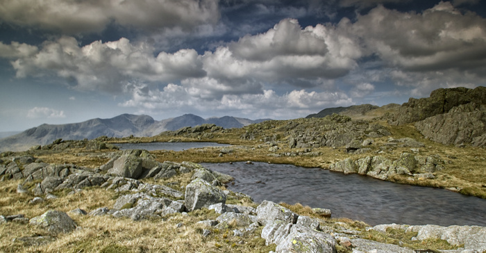
The summit of Little Stand, which is no more than an extension of the Crinkle Crags ridge, is isolated and serene. The summit cairn is accompanied by two small tarns (shown as one on the map). This is wild camping territory and I will be heading up here again soon with my tent to experience a sunset over the nearby Scafell Fells that rise in rocky majesty above the Duddon and Eskdale Valleys far below me.
A simple descent and gentle rise grants me access to the summit of Cold Pike. As I crossed the boggy ground high above Gaitscale Gill I came across a large number of canvas bags filled with large rocks. These had been dropped by helicopter and I can only assume this great effort has been to provide rocks to repair eroded routes. However, they have been placed a good kilometre from any obvious path! This makes me wonder; will the helicopter come again to move the rocks to their correct location, or will path workers have to man handle them over the rough ground? Both options seem inefficient to me (and the second option seems almost impossible, but I am aware of the Pyramids).
My last conclusion is that I have come across a 'rock storage bank'. This thought comes due to the distance from any main route, but also recognising this area is central to many popular climbing areas of the Lake District. Perhaps it is easier to store rocks high up in the Fells and move them over, what would now be relatively shorter distances(?) Similar to the logic of developing a moon base for expeditions to Mars. I guess this is an over top connection, but who knows.
From Cold Pike I drop to the Three Shires Stone that sits along the high road passing between Langdale and Duddon. This the meeting point of the 3 original counties that now make up this area known as Cumbria. They were original Lancashire, Westmoreland and Cumberland. The former losing its claim to some of this Mountain Real Estate and the latter two gone forever. Is this for the best?I do not know, but I am aware the history of these older counties can be tangibly experienced through the existing county boundary stones and markers across the district. Often useful navigation lines to be followed in mist and cloud.
My route now carried on up Wet Side Edge onto Great Carrs and to the memorial to a crew of Canadian Airmen who crashed and lost their lives high in these Fells during WWII. This memorial is both sad and beautiful as the waste of life is in contrast to the beauty of the surroundings and the nature of the memorial marker.
To finish the day I then headed up to the summit of Grey Friar and the took a long winding, indistinct path down the southern ridge. On my way down I came across a very old, man made track, not shown on the maps. This lead me,very conveniently, to my starting point.
I rarely stick to the traditional paths shown on the maps and therefore regularly come across these 'lost and forgotten' paths. What they were for is now lost in time, but they indicate how the Fells were once used, plus often provide new and very quiet insights into the mountains.
Rocky terraces and discovered paths.
Anticipating a busy day in the mountains (it is Easter Monday) I deliberately chose an area that is quiet and a route that is not obvious (as it is crossed by a road). This road is the high linking route between Little Langdale and Dunnerdale (Wrynose Pass).
The sun is bright and very high by the time I get myself into the hills. It is quiet. It is wonderfully quiet and peaceful and my progress is only hindered by my constant stopping to listen and watch the varied wildlife and take in the views. All around are the newly arrived Swallows and Wheatears. One oblivious of me as they flit and fall through the air, the other chattering in disgust as they try to lead me away from their territory.
Climbing Little Stand is hard work, but exciting as there are a series of rocky terraces, each 10m or more high that can be climbed. The choice of routes across this rock depends on mood and ability. For me I take very modest lines, but I enjoy every step and feel elated as I pull up on the dry, secure, high friction holds. The sense of physical power, awareness of the medium I am intimately engaged in adds to the sense of self fulfillment. This is a direct and very tactile interaction with the mountain. The experience focuses in, small and subtle, whilst, in contrast engaged in large effort, both physically and mentally.
The summit of Little Stand, which is no more than an extension of the Crinkle Crags ridge, is isolated and serene. The summit cairn is accompanied by two small tarns (shown as one on the map). This is wild camping territory and I will be heading up here again soon with my tent to experience a sunset over the nearby Scafell Fells that rise in rocky majesty above the Duddon and Eskdale Valleys far below me.
A simple descent and gentle rise grants me access to the summit of Cold Pike. As I crossed the boggy ground high above Gaitscale Gill I came across a large number of canvas bags filled with large rocks. These had been dropped by helicopter and I can only assume this great effort has been to provide rocks to repair eroded routes. However, they have been placed a good kilometre from any obvious path! This makes me wonder; will the helicopter come again to move the rocks to their correct location, or will path workers have to man handle them over the rough ground? Both options seem inefficient to me (and the second option seems almost impossible, but I am aware of the Pyramids).
My last conclusion is that I have come across a 'rock storage bank'. This thought comes due to the distance from any main route, but also recognising this area is central to many popular climbing areas of the Lake District. Perhaps it is easier to store rocks high up in the Fells and move them over, what would now be relatively shorter distances(?) Similar to the logic of developing a moon base for expeditions to Mars. I guess this is an over top connection, but who knows.
From Cold Pike I drop to the Three Shires Stone that sits along the high road passing between Langdale and Duddon. This the meeting point of the 3 original counties that now make up this area known as Cumbria. They were original Lancashire, Westmoreland and Cumberland. The former losing its claim to some of this Mountain Real Estate and the latter two gone forever. Is this for the best?I do not know, but I am aware the history of these older counties can be tangibly experienced through the existing county boundary stones and markers across the district. Often useful navigation lines to be followed in mist and cloud.
My route now carried on up Wet Side Edge onto Great Carrs and to the memorial to a crew of Canadian Airmen who crashed and lost their lives high in these Fells during WWII. This memorial is both sad and beautiful as the waste of life is in contrast to the beauty of the surroundings and the nature of the memorial marker.
To finish the day I then headed up to the summit of Grey Friar and the took a long winding, indistinct path down the southern ridge. On my way down I came across a very old, man made track, not shown on the maps. This lead me,very conveniently, to my starting point.
I rarely stick to the traditional paths shown on the maps and therefore regularly come across these 'lost and forgotten' paths. What they were for is now lost in time, but they indicate how the Fells were once used, plus often provide new and very quiet insights into the mountains.